
Amazing features around Lake Turkana, Kenya : Lake Turkana is amazing and rewarding for people who visit it. It has a lot of wildlife, such as water turtles, crocodiles, zebras, elephants, giraffes, snakes, scorpions, cheetahs, over 50 fish species, and many other animals.
Karsa, Kenya
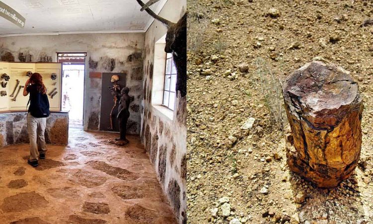
On the southeast edge of Lake Turkana in Turkana County, Kenya, is a basalt geological structure known as Karsa. It is also an archaeological site and a watering hole. Karsa volcanic flows are a kind of columnar jointed basalt that are found at the foot of significant sedimentary deposits in the Turkana Basin.
Karsa is situated in Turkana County, Northern Kenya, south of Koobi Fora and Sibilot, and east of Allia Bay on Lake Turkana. The area is dominated by sizable, angular stones that are the result of lava outcrops and is a portion of the volcanic highlands at the base of the Sibilot volcanic system. Older volcanic Karsa basalts have a spheroidal weathering pattern and date to the Miocene period, 14 million years ago. Two more recent basalt flows are joined in a columnar structure and date to the Pliocene period between 4.35 and 3.97 million years ago. The Koobi Fora formation is overlain by a shallow sedimentary succession that contains molluscs, which is in turn overlain by karsa basalts.
In an otherwise desolate area, Karsa serves as a watering hole for local fauna, and it is also a historical location where microliths from the Late Stone Age have been discovered. Karsa’s position is suitable for habitation due to the availability of water and its elevated vantage point over the area.
The Karsa formation was used by the Gabbra nomadic people as a watering hole for their livestock in the 20th century, particularly during water shortages. Fleece raids occasionally had Karsa as their goal. During the Second World War, Karsa served as the location of a police outpost for the governments of Kenya and the British Empire. In the first half of the 20th century, the King’s African Rifles of the British Empire were stationed there.
After the war, grazing restrictions were put in place at Karsa and in the neighbourhood.
Koobi Fora
The term “Koobi Fora” largely refers to the area surrounding Koobi Fora Ridge, which is situated on the eastern coast of Lake Turkana in the home range of the agrarian Gabbra people. The National Museums of Kenya claim that the name is derived from the Gabbra language.
Pliocene and Pleistocene sediments make up the majority of the ridge’s outcrop. It is made up of sandstones, clay stones, and siltstones, which are home to many fossilised terrestrial mammal species, including early hominin species. As of right now, a number of transient rivers that empty into the north-eastern corner of present-day Lake Turkana are eroding the ridge into a Badlands landscape. On a sizable sandbar jutting into the lake close to the ridge, which Richard Leakey termed the Koobi Fora Spit, he built the Koobi Fora Base Camp in 1968.
As a result, the Kenyan government designated the area as Sibiloi National Park in 1973 and built the National Museums of Kenya’s headquarters atop Koobi Fora Spit. The reserve is well-kept, and amiable but armed park police are on duty to keep it safe. The preservation of locations and, in particular, animals, is of utmost importance. The Koobi Fora Research Project (KFRP), which works with numerous interested colleges and people around the world, continues exploration and excavation.
Previously, the phrase “Koobi Fora” was used to refer to one or two original sites or the sand spit. It can now refer to any or all locations inside Sibiloi National Park. Additionally, the phrase East Turkana is now frequently used with a wider definition.
Archaeological site
The following is a straightforward hierarchy of Koobi Fora’s scientific locations: The area is known as Koobi Fora; it is divided into fossil collecting areas (such as Area 102, 103, 140, etc.); within these areas are archaeological sites (such as FxJj 1, FxJj 10, etc.) and hominin palaeontological localities, which are typically named after the National Museum of Kenya accession number given to the significant bones discovered. For instance, the hominin skull KNM-ER 1470 was discovered in Area 131. All of the non-human fossils discovered here are attributed to the location 1470.
Fossils are identified by a KNM (Kenya National Museums) accession number, which is only given in the order it was given. In academic writing, the number may be preceded by KNM, KNM-ET, KNM-ER, or just plain ER, where ET and ER stand for East Turkana and East Rudolf, respectively. The following are some noteworthy regions.
Area 105
Area 105 is the location of the first archaeological site, known as FxJj 1. It is also known as the KBS site, or Kay Behrensmeyer Site, in honour of the researcher who made the first stone tool discovery there. The KBS Tuff, the first tuff, was discovered at this location as well.
Area 131
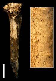
It is well-known as the site of Skull 1470, which Richard Leakey later rebuilt and dubbed Homo habilis as perhaps the first member of the genus Homo. Skull 1470 was found by Bernard Ngeneo in 1972, rebuilt by Meave Leakey, and finally rebuilt. Once Richard Leakey discovered Homo rudolfensis beneath the 1.89 million-year-old KBS tuff, it was usually believed to be that age even though it is older.
Hominin fossils
Another challenging issue is searching for and discovering fossils in such a broad area. One option has been to get everyone there into a group and have them sweep a specific area. Richard Leakey came up with a technique that worked better: he organised and trained a Kenyan search squad known as “the hominid gang”—“hominid” being the term used at the time for the modern definition of “hominin”—under the direction of Kamoya Kimeu. Most of the 200 or so hominin fossils that have been found so far were discovered by them.
Although specimens of the genus Australopithecus have also been discovered, those from the genus Homo are probably most recognised for having been uncovered at Koobi Fora.
Turkana Basin
East Africa’s greater Turkana Basin, which includes primarily north-western Kenya and southern Ethiopia as well as smaller portions of eastern Uganda and southeast South Sudan, creates a sizable endorheic basin, a drainage system with no outflow, that is centred on the Gregory Rift system in Kenya and southern Ethiopia. The Gregory Rift’s endorheic Lake Turkana, a brackish soda lake with a high biological productivity, is the deepest point in the basin.
The name “Turkana Basin” is also frequently used to refer to the region surrounding Lake Turkana in Kenya and Ethiopia, specifically within the boundaries of the Gregory Rift. This encompasses Ethiopia’s lower Omo River valley. According to a more specific definition, the Basin is a location of geological subsidence that is home to one of the Plio-Pleistocene’s most continuous and temporally well-controlled fossil records, some of which date back to the Cretaceous. Lothagam, Allia Bay, and Koobi Fora are three important fossiliferous sites in the Basin.
The Lotakipi Plains to the north, the Karasuk to the west, the Chalbi Desert to the east, and the Samburu to the south surround Lake Turkana, which is located in the middle of the Turkana Basin. These areas include open grasslands, scattered acacia, and desert scrub. They also include desert grassland and shrub land. The Omo River in Ethiopia, located in the northern half of the basin, is the only genuine perennial river. It empties into the lake on its northern side and provides it with more than 98% of its annual water inflow. The Turkwel River and the Kerio River in Kenya, in the western half of the basin, are the two intermittent rivers that almost exclusively contribute the final 2% of water inflow. Today, the Turkana Basin might be characterised as a large area of arid scrubland or even desert. The valley of the Omo-Gibe River in the north is an exception.
The Turkana Basin is home to significant cities like Lokitaung, Kakuma, Lodwar, Lorogumu, Ileret, and Kargi. The Samburu and Pokot people live in the south of the Basin, while the Nyangatom, Dassanach, and Borana Oromo people are in the north and east. The Turkana people live in the west of the Basin.
